From our front-page news:
Google has unveiled a major upgrade to their popular Google Earth application, bringing it to version 5.0. Like most Earth upgrades, the feature additions to this one are well-worth checking out. One of the coolest features is the addition of being able to go underwater and see things from that perspective. Don't expect a Street View-type experience, though. You won't see wildlife, shipwrecks or anything like it.
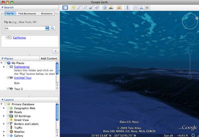
The goal here is to see what the elevation is like in certain parts of the ocean. There's a new "Ocean" menu which will fill the ocean with numerous icons to read more information on what went down there, or why it's particularly interesting. If the ocean isn't interesting to you, then perhaps the "Historical Imagery" feature will be. Like it sounds, it will allow you to look back in time in certain areas, as long as the imagery exists.
Finally, if you've ever wanted to explore Mars, here's your chance. Exploration works the same as on Earth, so you can zoom in and out to see whatever might catch your eye. The entire planet is also littered with various bits of information, including the Mars Rover path, crater names, path names, et cetera. Overall, this is a great upgrade, and packs even more value into an already great tool.
This controller is pretty handy, as it contains buttons for stepping back through any significant historical changes that Google has on file for a particular location. Using either the buttons or the timeline scrubber, Google Earth will seamlessly pull down past satellite images and any other data Google has to swap into the current view.
Source: Ars Technica